
I was mapping Mills Mills falls and Wiscoy Falls and saw this on the topo and Satellite images, it looks like a falls... I don't see anything about it.
MAP
Waterfall on Wiscoy Creek
-
Matt

- President

- Posts: 13374
- Joined: Sun Apr 23, 2006 5:01 pm
- Camera Model: Olympus OMD EM-1 m1, m2; Panasonic GM5, Osmo Pocket
- Location: Rochester, NY
- Contact:
-
cbobcat49

- Moderator
- Posts: 1807
- Joined: Wed May 24, 2006 7:19 pm
- Camera Model: Olympus Stylus 400
- Location: Tonawanda, NY
- Contact:
It sure looks like a falls. What is that road on the bottom left? And is that Wiscoy Creek? If I knew what some of those landmarks were I may know if its a falls I've been to or not. If its not, it might be something worth investigating! 
-
Matt
- President
- Posts: 13374
- Joined: Sun Apr 23, 2006 5:01 pm
- Camera Model: Olympus OMD EM-1 m1, m2; Panasonic GM5, Osmo Pocket
- Location: Rochester, NY
- Contact:
It is Wiscoy creek and the road is Armison Rd. Look like a drop of about 10 feet acording to the topo info.
-
cbobcat49
- Moderator
- Posts: 1807
- Joined: Wed May 24, 2006 7:19 pm
- Camera Model: Olympus Stylus 400
- Location: Tonawanda, NY
- Contact:
aha! Now I see exaclty where that is in my Gazeteer. Just downstream from Mills Mills Falls. (which isn't a natural falls - manmade, if I remember right) We were there about 3 years ago and downstream looked like a promising creekwalk but there were very serious looking Posted, No Tresspassing signs at the obvious place where you'd enter in to start walking downstream... so we didn't. I suppose it would be worth going back there to see if there's a name and address on those signs and asking permission. I've had success just asking before. Its worth a try.
Chris
Chris
-
cbobcat49
- Moderator
- Posts: 1807
- Joined: Wed May 24, 2006 7:19 pm
- Camera Model: Olympus Stylus 400
- Location: Tonawanda, NY
- Contact:
see the above post.
-
RockvilleBill
- Rookie
- Posts: 2
- Joined: Thu Mar 08, 2012 12:30 pm
- Location: Buffalo
[img2]http://i40.tinypic.com/35n0v29.jpg[/img2]
Beautiful Falls, if you hike to the top there's also a 40' high dam which has water cascading over creating a manmade 40' falls. You can't see it from the road. The water actually hurts if you try to get beneath it. There's also a couple of water created potholes about 15' in diameter and about 15' deep that you can jump off a ledge into. The last time I went alot of people were doing it. I did it 2x. The first time I didn't even touch the bottom! The second time I did barely, so I'm just estimating the depth. I got talked into jumping. Locals were diving head first but not me. When you get to the edge of the hole it's only 1' deep.
Beautiful Falls, if you hike to the top there's also a 40' high dam which has water cascading over creating a manmade 40' falls. You can't see it from the road. The water actually hurts if you try to get beneath it. There's also a couple of water created potholes about 15' in diameter and about 15' deep that you can jump off a ledge into. The last time I went alot of people were doing it. I did it 2x. The first time I didn't even touch the bottom! The second time I did barely, so I'm just estimating the depth. I got talked into jumping. Locals were diving head first but not me. When you get to the edge of the hole it's only 1' deep.
Last edited by Kelly on Thu Mar 08, 2012 9:42 pm, edited 1 time in total.
Reason: Switched to IMG2 tag
Reason: Switched to IMG2 tag
-
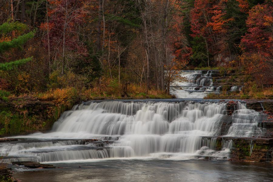
SteveLig2
It's off of Rt 19A below Letchworth State Park and is worth the drive. I didn't see a way to hike on land but I think you can go up the stream bed. This shot was taken from the bridge.

Last edited by Kelly on Tue Oct 21, 2014 1:35 pm, edited 1 time in total.
Reason: Fixed image link. :o)
Reason: Fixed image link. :o)

