Page 1 of 7
Deckertown Falls
Posted: Thu Sep 06, 2007 4:47 pm
by cbobcat49
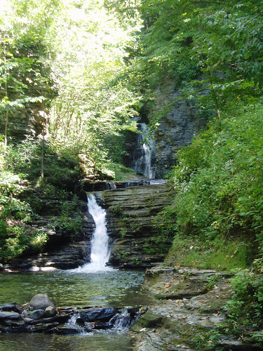
This is on Catlin Mill Creek on the east side of the village of Montour Falls. There's a series of 5-6 small to medium sized falls on this creek. This photo shows the first 2. It's impossible to creekwalk the whole way up the creek but there's a trail that goes along the right side at the top of the gorge and you can look down in. The trail follows the path of an old raceway. You can see places where it was cut right through the shale rock. Very interesting.
The owners of the B&B we stayed at said that the creek itself is owned by the village and many citizens have been lobbying to get a park established there. So far there's only a green sign that says "Catlin Mill Creek Waterfalls". (or something like that) The woods opposite the gorge trail (on the right, opposite the creek) is heavily posted so try not to venture off into the woods if you go here.
Posted: Thu Sep 06, 2007 8:24 pm
by Matt
interesting. Looks like a good amount of flow too. A park would be nice. Hopefully in the future, as we grow, we can help support fundraising for development of parks.
Re: Deckertown Falls
Posted: Sun Feb 28, 2010 4:01 am
by spec
What's the best way to get in there? I'm looking on Google Earth right now and it looks like E Catlin Street goes into the woods to a parking area. Is this correct? I also see there's a park or something on the other side of L'Hommedieu. The road is labelled Catherine Creek Park Rd. I'm thinking if Catlin St is a no-go, best bet would be to park in here, drop into the creek and head upstream.
I'm planning this to be one of my first climbs/treks this upcoming season. I'm hoping to conquer this, Havana Glen (Eagle Cliff and beyond), and Excelsior Glen in one day. I know I can do Excelsior round trip in roughly 2hrs, so I'm thinking I'd hit there first, head down to Deckertown, then to Havana Glen.
Re: Deckertown Falls
Posted: Sun Feb 28, 2010 8:28 am
by cbobcat49
You can park at the end of Catlin St.
So you think there's more falls in Havana Glen above Eagle Cliff? We saw kids up at the top of Eagle Cliff Falls last time we were there but we had no idea how they got up there.
Re: Deckertown Falls
Posted: Sun Feb 28, 2010 11:09 am
by spec
(This should probably be in the Havana Glen thread, but what the hey...

)
I think there's at least one, maybe two good sized falls and possibly a few more smaller ones. I can't really tell with Google Earth, and Bing has no good imagery for this area (bummer).
Going upstream from Eagle Cliff, the creek goes east for a ways with perhaps a few smaller cascades along the way -- too many trees on Google to tell. The creek then makes a sharp turn to the south, then another quick turn back east and from the perspective I see on google, it looks like the creekbed is "closer to the camera" at that eastern turn, which to me infers a good drop. Beyond that, another sharp turn due south, then back east again. The stretch between turns looks like it may be similar to "Lower Cascades" (my name for it) in Conklin Gully -- a narrow channel dropping at a relatively shallow angle over a few "steps" in the rock, with 90 degree turns at both ends. Makes for a falls that is longer than it is tall. Now, it looks like the creek goes east (again, going upstream) for a ways in a deeper chasm, which bends a bit to the north. At the east end of this chasm, the creek again "comes closer," which again infers a falls, but I can't really tell with Google. There's another sharp southern turn here, and there doesn't appear to be anything else upstream from this. Topo appears to corroborate all this, tho I could be waaaaaay off.
I'm very much looking forward to finding out! Unfortunately it's not really situated in an area where I can run visual recon this time of year, so it'll have to wait til things thaw out a bit. My main concern is land ownership. Anyone have links to Schuyler County GIS or tax maps? I've not been able to find much, but I also haven't spent too much time looking.
RE: getting to the top of Eagle Cliff... I'm sure Ben and I will find a way up to the top. That man is part monkey I swear. My main challenge when climbing is finding a good line to follow. Ben seems to be able to pick 'em out quite readily, and If he can find a way up, I can follow him. From looking at the pictures and topo, I'm thinking we'll probably end up climb up the gorge a bit downstream from the falls if we can and then drop back into the gorge above the falls. However we do it (and we will), I'll be sure to document it and share it here so others might be able to get up there too.
spec
Re: Deckertown Falls
Posted: Sun Feb 28, 2010 11:45 am
by hobkyl
Hmmm... for some reason the GIS maps are not working on Schuyler county's website. I would try contacting them. This is all I could find...it would be a starting point at least.
http://schuyler.sdgnys.com/quickstream. ... 087000.pdf
Re: Deckertown Falls
Posted: Sun Feb 28, 2010 2:32 pm
by cbobcat49
I'm checking out Google Earth right now. I see all those twists and turns you're talking about. You're right, when a creek does that there's a good chance there's some falls in there. I'm wondering if there's a trail to the upper part of the creek somewhere near the campground in Havana Glen Park? (on your right as you're driving through the park towards the falls.)
Re: Deckertown Falls
Posted: Sun Feb 28, 2010 4:11 pm
by hobkyl
For some reason the map isnt showing up from the link...yet it worked when I previewed it. Anyway...if you click on "Public Access" and then search properties along Havana Glen Road leaving the rest of the fields blank; a list of all properties on that road will come up. From there click the link for the first "Tax ID" which will bring you to a page specific for that property which you can find all tax related information on the property (ie: owner/address) Once you do that on the right side you will see "Maps". Click on "Show Tax Map (pdf) and it will bring up a map of the properties near the creek.