
gardengirl3,
If you go up to the tab that says "Waterfalls" (right above) and click on the map you will find a whole new world. Matt has put together a great way to find out where waterfalls are and has tagged each waterfall with a posting so you can read about the location, how to get there, cautions, etc.
For Fawn's leap i parked on the side of the road because others were parked there right by the sign. I don't recall any posting that said you couldn't. And Yes i used the 24-105 lense. Best way to get that aerial shot is to cross over the falls from above and follow the trail.
The bridge L_G_D mentioned is over Moore's Bridge Falls. Again, check out the "waterfalls" tab above. Good luck!
Fawn's Leap Falls
-
ApproachingLight

- Board Expert

- Posts: 871
- Joined: Thu Jul 29, 2010 9:19 am
- Location: Rochester
- Contact:
-
L_G_D
- Board Expert
- Posts: 629
- Joined: Fri May 29, 2009 2:29 pm
- Camera Model: Sony Alpha 700
- Location: Capital District area, upstate NY
Yeah, Moore's bridge, about halfway up the clove from Palenville, before you get to the hairpin turn at Bastian Falls where the trail to Kaaterskill is. I was there Saturday, on the way to North South Lake State Park (another place to check out if you're in the area, the site of the old Mountain House is a great view, as are the hikes along the cliffs to Artist's Rock, Newman's Ledge, and Sunset Rock). There are some "no standing" signs along the road now, and the new guard rails block most of the old parking places. There are a couple of very tiny places to just get a car off the road just below the bridge, and just up from the sign for Fawn's Leap, but they are really small and could maybe fit one car. There is one a little ways below the bridge where you might be able to fit two cars. We usually park at Rat Hole and walk up, it's just easier. Plus there are a couple of nice places to shoot along the way.
LGD
-
gardengirl13
- Senior

- Posts: 117
- Joined: Thu Nov 11, 2010 10:04 am
- Camera Model: OMD-EM5
- Location: Hudson Valley
- Contact:
Oh that waterfalls tab with the map is much easier to use! Thanks so much!
LGD we tried North South Lake and they had everything barricaded off. We plan on trying again. I heard there is a waterfall on Mary Glen trail and that the trail is supposed to be fairly easy. I'm dying to see the view from the old mtn house!
Has anyone shot the falls on 23? If you go up past hunter and turn right onto 23 just up the road a little bit is a waterfall before you get to Ashland. There is no where to park, but if you park up the road and walk I assume you won't get into too much trouble. But I don't think there is public access to the base? But it's quite pretty. I plan on stopping on the way up for thanksgiving next week. I'll post the photos in a new thread. I just don't know the name of the falls for the title.
to see my photos http://www.pbase.com/gardengirl13/
-
L_G_D
- Board Expert
- Posts: 629
- Joined: Fri May 29, 2009 2:29 pm
- Camera Model: Sony Alpha 700
- Location: Capital District area, upstate NY
I've never been to those falls, will have to keep it in mind. The park around North South Lake is closed for the season, so you have to walk around the lake to get to anything. In the summer, you can drive to the beach or around the other way to the last parking lot to walk a short distance to the Mountain House site. Ashley Falls is in Mary's Glen, the bottom part, and is an easy though rocky & wet walk from the nearest parking, but that's closed off for the winter, you have to walk down the road, which is what we did.
LGD
-
hobkyl

- Moderator

- Posts: 2671
- Joined: Thu Aug 14, 2008 8:55 am
- Camera Model: Pentax K30
- Location: Victor, NY
Awesome falls...wish I could have gotten out into the creek some...but didnt dare.
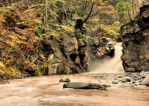
Fawn's Leap Falls by hobkyl, on Flickr
Fawn's Leap Falls by hobkyl, on Flickr
-
Mystiqz
- Rookie
- Posts: 4
- Joined: Sun Apr 22, 2012 4:39 pm
- Camera Model: Canon 5d Mk 2, 16-35mm II, 70-200 vI
- Location: NYC
I am thinking of hiking to this fall with my dog towards the end of Jan 2014, does anybody know where I can park and then start to hike towards the falls? I"d greatly appreciate any help/advice.
-
L_G_D
- Board Expert
- Posts: 629
- Joined: Fri May 29, 2009 2:29 pm
- Camera Model: Sony Alpha 700
- Location: Capital District area, upstate NY
Unfortunately, last time I was through there, all the parking lots had been barricaded or blocked in some way, even the one down at the bottom across from the Rat Hole. I don't know why. The only one still open is uphill a fair distance near the old tannery site. You can't miss it, but it would be a bit of a walk down the road to Fawn's Leap, and there isn't a lot of shoulder to walk on in a lot of places, take care if you do. Walking in the woods just off the road might be a better bet in some spots, or even just follow the stream down.
That is, unless the tannery one is blocked now as well, I haven't been through there in a few months.
That is, unless the tannery one is blocked now as well, I haven't been through there in a few months.
LGD
-
Mystiqz
- Rookie
- Posts: 4
- Joined: Sun Apr 22, 2012 4:39 pm
- Camera Model: Canon 5d Mk 2, 16-35mm II, 70-200 vI
- Location: NYC
thanks for the info. I wonder why they did that. making it more difficult to enjoy nature.
LGD: would you happen to have the approx. google GPS coordinates for the Old Tannery site?
Thanks in advance.
LGD: would you happen to have the approx. google GPS coordinates for the Old Tannery site?
Thanks in advance.

