
Ohh ok I've never been up the south rim of the gorge. Not 100% sure if that way is off-limits but all of those posted signs send me across the creek. I checked out the tax maps and it looks like private property right up to the south side of the gorge and the owner lives on the street. My best guess is that the south rim is not ok and all those posted signs are there to say so. On the other hand the North rim appears to be in some sort of land trust that extends roughly up to the bridge. Beyond that is private and the lines seem to coincide with the posted signs I saw above the bridge.
Anyhow, probably best to only "advertise" the lower falls. The tax maps seem to suggest that only the North rim is ok and only up to the bridge. Everything else is private.
http://www.stcgis.org/schuyler/#
Deckertown Falls
-
bremer
- Senior

- Posts: 136
- Joined: Wed Apr 29, 2009 11:06 pm
- Camera Model: Sony Alpha 230
- Location: Blacksburg VA
- Contact:
"Now I see the Secret of the making of the best persons. It is to grow in the open air and to eat and sleep with the earth" - W. Whitman
Roots Photography
Roots Photography
-
hobkyl

- Moderator

- Posts: 2671
- Joined: Thu Aug 14, 2008 8:55 am
- Camera Model: Pentax K30
- Location: Victor, NY
That's the way I recall it too. Maybe 50-100 ft from the creek edge to the signs.
-
Matt

- President
- Posts: 13374
- Joined: Sun Apr 23, 2006 5:01 pm
- Camera Model: Olympus OMD EM-1 m1, m2; Panasonic GM5, Osmo Pocket
- Location: Rochester, NY
- Contact:
i recall seeing signs, maybe 6 of them, but they seemed to line the right of the trail. to keep people from wandering off of it. I'll note that on the page I write. I'll probably cut out that last tail of the trail on the map. I'm sure I climbed town and headed upstream, found nothing then turned around and went back.
-
cbobcat49

- Moderator
- Posts: 1807
- Joined: Wed May 24, 2006 7:19 pm
- Camera Model: Olympus Stylus 400
- Location: Tonawanda, NY
- Contact:
I know you're definitely ok taking the trail all the way up to the bridge. The land immediately to the right of the trail is definitely posted.The land to the right of the trail is posted. It always has been, but it seems the trail itself, and that small sliver of land doesn't have signs. Not 100% sure though.
What lies behind us and what lies ahead of us are tiny matters compared to what lives within us. ~Henry David Thoreau
-
bremer
- Senior
- Posts: 136
- Joined: Wed Apr 29, 2009 11:06 pm
- Camera Model: Sony Alpha 230
- Location: Blacksburg VA
- Contact:
Good to know I will have to try that trail sometime. The taxmap has the boundary running down the center of the creek... Either the boundary is off or the landowner is allowing people to come on his property and skirt the gorge. Either way it seems there must be a missing easement that is not on the map because there would be no way to get to the public land from the end of Catlin St. I would recommend the north rim if you haven't tried it... you get a head-on view of the largest falls and you are safely on land-trust property (I think). There is also an old metal railing along the trail at the point of the falls overlook. Probably a remnant of its days as a park.I know you're definitely ok taking the trail all the way up to the bridge. The land immediately to the right of the trail is definitely posted.
"Now I see the Secret of the making of the best persons. It is to grow in the open air and to eat and sleep with the earth" - W. Whitman
Roots Photography
Roots Photography
-
cbobcat49
- Moderator
- Posts: 1807
- Joined: Wed May 24, 2006 7:19 pm
- Camera Model: Olympus Stylus 400
- Location: Tonawanda, NY
- Contact:
cool! I've got to head up there the next time we're there.I would recommend the north rim if you haven't tried it... you get a head-on view of the largest falls and you are safely on land-trust property (I think). There is also an old metal railing along the trail at the point of the falls overlook. Probably a remnant of its days as a park.
What lies behind us and what lies ahead of us are tiny matters compared to what lives within us. ~Henry David Thoreau
-
Matt
- President
- Posts: 13374
- Joined: Sun Apr 23, 2006 5:01 pm
- Camera Model: Olympus OMD EM-1 m1, m2; Panasonic GM5, Osmo Pocket
- Location: Rochester, NY
- Contact:
Interesting... can you draw that on the map for reference?bremer wrote:Good to know I will have to try that trail sometime. The taxmap has the boundary running down the center of the creek... Either the boundary is off or the landowner is allowing people to come on his property and skirt the gorge. Either way it seems there must be a missing easement that is not on the map because there would be no way to get to the public land from the end of Catlin St. I would recommend the north rim if you haven't tried it... you get a head-on view of the largest falls and you are safely on land-trust property (I think). There is also an old metal railing along the trail at the point of the falls overlook. Probably a remnant of its days as a park.I know you're definitely ok taking the trail all the way up to the bridge. The land immediately to the right of the trail is definitely posted.
-
hobkyl
- Moderator
- Posts: 2671
- Joined: Thu Aug 14, 2008 8:55 am
- Camera Model: Pentax K30
- Location: Victor, NY
Well at least one creek was flowing today in the Watkins Glen area. I stopped by all with the exception of Havana. All bone dry, or very very low flow. I forgot to count the number of falls, as I said I would...will have to go back, oh well. Perhaps that fall outing-Matt?
A few things to note...
The pool at the very bottom falls (lemon squeezer) has been dammed. Nice for the locals however not so nice for hikers. This makes it impossible to go up the left side to the main falls. You have to go up the trail, and then cut back down a trail that is fairly young but has seen some use and will get you back down to see the falls.
The trail going up beyond those falls towards the 224 bridge, has a chain with a Private Property sign on it hanging across the trail. I dont know if the land changed ownership or what, but it has always been generally acceptable to climb further up the creek staying to the left of the signs. Since there were no other signs in the immediate vicinity, we made a decision to skirt around the chain just to left. Not sure if the status has changed, wasn't marked properly to begin with, or the landowner is overstepping his boundaries.
Anyway, here is a quick one...will get to more later.
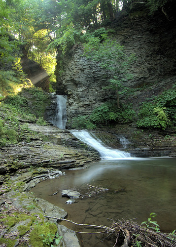
Shinedown by Kyle Hobart, on Flickr
A few things to note...
The pool at the very bottom falls (lemon squeezer) has been dammed. Nice for the locals however not so nice for hikers. This makes it impossible to go up the left side to the main falls. You have to go up the trail, and then cut back down a trail that is fairly young but has seen some use and will get you back down to see the falls.
The trail going up beyond those falls towards the 224 bridge, has a chain with a Private Property sign on it hanging across the trail. I dont know if the land changed ownership or what, but it has always been generally acceptable to climb further up the creek staying to the left of the signs. Since there were no other signs in the immediate vicinity, we made a decision to skirt around the chain just to left. Not sure if the status has changed, wasn't marked properly to begin with, or the landowner is overstepping his boundaries.
Anyway, here is a quick one...will get to more later.
Shinedown by Kyle Hobart, on Flickr

