
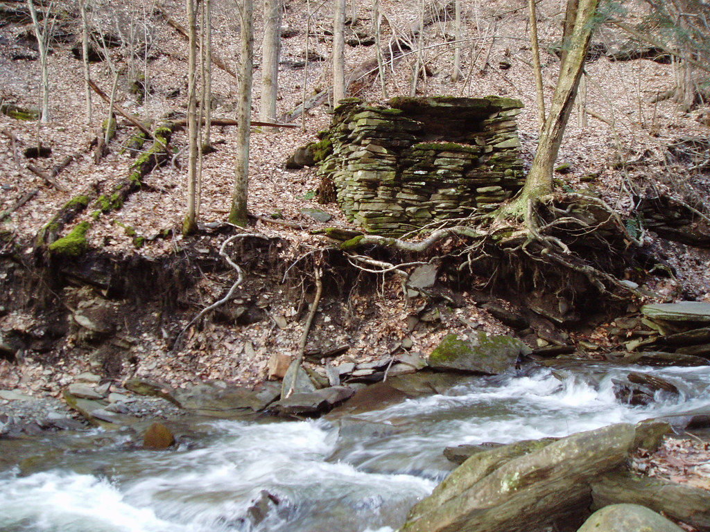
It's about 6' square and 4' high if memory serves me right. I can't remember if I took a picture or not. I'll check when I get home. It looks very old. Lots of moss growing on it.
Chris
Reynolds Gully - Livingston County
-
cbobcat49

- Moderator

- Posts: 1807
- Joined: Wed May 24, 2006 7:19 pm
- Camera Model: Olympus Stylus 400
- Location: Tonawanda, NY
- Contact:
-
cbobcat49
- Moderator
- Posts: 1807
- Joined: Wed May 24, 2006 7:19 pm
- Camera Model: Olympus Stylus 400
- Location: Tonawanda, NY
- Contact:
I found a picture of it. It almost looks like the foundation for a bridge. But there definitely isn't a corresponding one on the other side.
-
Matt

- President
- Posts: 13374
- Joined: Sun Apr 23, 2006 5:01 pm
- Camera Model: Olympus OMD EM-1 m1, m2; Panasonic GM5, Osmo Pocket
- Location: Rochester, NY
- Contact:
looks like a very early construction. Possibly for a mill. But its not even mortared. So it could even be something someone just did for kicks. maybe try to build a bbq or something. I wouldn't expect it to last long at all in a watershed not being mortared or have a foundation.
-
wtd
hey there,
nice site, have you ever read 200 Waterfalls in Central & Western New York: A Finders' Guide?
There is a picture of Reynolds Gull on the back cover and inside the book it says that there are "2 falls 15 and 20-feet high on public property" and "Two falls 12 and 70-feet high on private property".
These pictures can be found at the blog of WTD --> http://loveyourdestiny.blogspot.com

[The highest falls on occupied territory]

[I have also always wondered what that structure is all about...]
nice site, have you ever read 200 Waterfalls in Central & Western New York: A Finders' Guide?
There is a picture of Reynolds Gull on the back cover and inside the book it says that there are "2 falls 15 and 20-feet high on public property" and "Two falls 12 and 70-feet high on private property".
These pictures can be found at the blog of WTD --> http://loveyourdestiny.blogspot.com
[The highest falls on occupied territory]
[I have also always wondered what that structure is all about...]
-
Matt
- President
- Posts: 13374
- Joined: Sun Apr 23, 2006 5:01 pm
- Camera Model: Olympus OMD EM-1 m1, m2; Panasonic GM5, Osmo Pocket
- Location: Rochester, NY
- Contact:
The owner contacted me and told me they have a huge problem with tresspassing. I guess a lot of people have gotten hurt or stuck in there.
They've adopted a no tolerance policy on the tresspassing.
So be careful in that area.
I think the section that is acessible is pretty nice, but not really worth a trip. I haven't been beyond the posted signs. The falls don't look like it's worth risking tresspassing or getting stuck.
County line falls seems to be a better bet when in that area.
Thanks for posting the pictures.
-
wtd
Indeed, I don't want to encourage trespassing. I've also heard of folks getting hurt there, so be careful and don't trespass, it can be a rather difficult hike, especially when it is wet out, I've taken many a fall (on the public side of course). Now that I think of it, I'm not sure how I obtained the photo of the high falls there, must have been someone else...
Although, the thing that is nice about this spot is that for all those folks who live in Hemlock and the surrounding community and can't legally swim in Hemlock Lake on a hot summer day, you can legally take a dip into one of the cold pools on the public side of the gull, which can be quite refreshing.
On a similar note, I noticed that the top banner on your homepage of nyfalls.com looks like it was taken from the north end of Hemlock Lake looking south... is this correct? I think I could identify that view in my sleep if I had too. Again, thanks for the lovely site.
-
Matt
- President
- Posts: 13374
- Joined: Sun Apr 23, 2006 5:01 pm
- Camera Model: Olympus OMD EM-1 m1, m2; Panasonic GM5, Osmo Pocket
- Location: Rochester, NY
- Contact:
good eye!
Yes, the waterscape is Hemlock looking south. It's combined with lower falls from Letchworth, and the bottom of the site is the base of the American Niagara Falls.
So how familiar are with the Hemlock shore? Are there any more gullies dumping into it?
When I look at the Topo map there are some possibilities. Here's a marked map. MAP
-
cbobcat49
- Moderator
- Posts: 1807
- Joined: Wed May 24, 2006 7:19 pm
- Camera Model: Olympus Stylus 400
- Location: Tonawanda, NY
- Contact:
Those MAY have intermittent falls on them. Not to discourage you but I know that area is VERY steep and thick with brush. We did a canoe trip with Pack Paddle & Ski 2 summers ago and we hiked down (slid, stumbled) to the lake from right around that area that you have marked. The streams don't seem like they have much of a watershed either. But hey, part of the fun is checking it out.  Who knows, there may be something interesting there.
If you click to the right and down on that map you posted, there is a promising looking gully flowing into the southeast part of Canadice Lake that I've got on my to do list to check out.
Also, my wife noticed once that the surface elevation of Canadice Lake is WAY higher than that of Hemlock. Is there a falls on Canadice Outlet? I've gotta check that out some time too!
Chris

