
Typical. "Got some beautiful land? Subdivide it!"
Three Falls Woods
Located in the triangle between Sweet Road, Route 173, and Troop K Road, the Three Falls Woods is 175 acres of hardwood forest, a maze of paths, trees, water, and rock outcroppings most easily accessed at the end of Glencliffe Road.
The Character of Three Falls Woods
• Three distinct waterfalls are formed by two tributaries of Limestone Creek as they tumble sixty feet over the edge of the Niagara Escarpment. The two streams join together on the valley floor.
• Towering cliffs surround the floodplains of the valley floor; a braided streambed meanders along, occasionally filled with water after heavy rains.
• Protected species of flora have been documented as present in the woods; local legend includes the Hart’s-tongue Fern (Asplenium scolopendrium var. americanum), which is a NYSDEC Threatened species.
• The land was historically used as farmland, horse pasture, and light quarrying; left to revert to a natural state over 150 years ago, old rock walls and cavalry bridle paths still crisscross the forest.
•It is the largest uninterrupted piece of forest for at least ten miles around, part of a 7-mile long wooded corridor, providing key wildlife habitat to many species.
•Over 65 different species of mosses have been documented thus far; many more have yet to be identified. Such diversity and abundance is found in few other places.
• It is a recreational resource for the community. Many people in the surrounding area enjoy walking, skiing, snowshoeing, biking, exploring, and birdwatching together in these woods.
Past Threats to the Land
• Thirty years ago the town land was owned by Allied. When they applied for a zone change to quarry the lands in the Town of Manlius, Citizens Organized to Protect the Environment (COPE) was formed and opposed it. Compromise included mining in one area, a buffer, and protection of the land from mining on the rest. It was believed that the resulting agreement between Allied and the Town required the land in the Town to be kept in its natural state forever.
• In the past twenty years, two subdivision plans have been filed by various developers. In each case, some residents fought it and the plans were tabled… for the moment.
The Current Threat to the Land
The owner of most of the land, William Camperlino, submitted subdivision proposals to the Town and the Village in 2004 for the development of Three Falls Woods.
Village of Manlius Subdivision Proposal, submitted June 21, 2004:
• Proposes 95 lots on 44.5 acres of land.
• SEQR short form denies any environmental impact will result from the project.
• At least six houses will be situated on the floodplain at the end of Glencliffe.
• Sketch subdivision plan was proposed last June: Camperlino was told he needed a better plan by the Village Planning Board, and has not come back… yet.
Town of Manlius Subdivision Proposal, submitted June 7, 2004:
• Proposes 85 lots on 131 acres of land.
• Currently zoned Rural Agricultural (R-A) and Residential (R-1).
• Plans for expensive homes on large lots.
• Plans for elderly housing above the waterfalls.
• Use of floodplain land at Fillmore Corner for convenience shopping.
• Proposed entrances off of Sweet Rd. and to the south of Limberlost Lane.
• Sewer access expected due to the past acquisition of two properties: the Limberlost Lane property and one in the Village of Manlius.
• Proposal will be done in 10 phases, starting with single family homes for the next 5 years.
The first step, an attempted subdivision of one residential lot on Limberlost Lane, was for the purpose of getting sewer access for the future development. This was stopped by the Appletree Ridge Association, by filing an Article 78 lawsuit against the town for not following their own rules in deciding to approve the subdivision. It is expected that the Town will not contest it, rendering the subdivision void and the developer will have to resubmit everything again.
http://www.manliusgreenspace.org/3fallswoods.html
Three Falls Woods
-
champy1013
- Lead Contributer

- Posts: 708
- Joined: Sun Apr 10, 2011 12:45 pm
- Camera Model: Canon EOS 5D Mark IV
- Location: Skaneateles
Last edited by Matt on Thu Mar 26, 2009 9:11 am, edited 1 time in total.
Reason: added the poll
Reason: added the poll
-
champy1013
- Lead Contributer
- Posts: 708
- Joined: Sun Apr 10, 2011 12:45 pm
- Camera Model: Canon EOS 5D Mark IV
- Location: Skaneateles
it really would be a shame if that went through. Found some shots of it:
http://www.pbase.com/syrcam/threefalls
Looks beautiful. I emailed the manlius greenspace committee to check the current status of the land and if we could offer any assistance on our site (maybe getting a profile page up for it or something)
http://www.pbase.com/syrcam/threefalls
Looks beautiful. I emailed the manlius greenspace committee to check the current status of the land and if we could offer any assistance on our site (maybe getting a profile page up for it or something)
-
Matt

- President
- Posts: 13374
- Joined: Sun Apr 23, 2006 5:01 pm
- Camera Model: Olympus OMD EM-1 m1, m2; Panasonic GM5, Osmo Pocket
- Location: Rochester, NY
- Contact:
I recall looking into this area a few months back... The landowner lets the community access the property. People thre love it and I'm sure they will let him know what they think.
On the other hand that's a lot of tax revenue for the village... and I'mm 100% sure mopney rules out over anything else for upstate government.
If people can comfrim the presence of old growth forest and/or endangered species, the development could be limited at the very least.
Here's the website slideshow for ths site:
http://www.manliusgreenspace.org/slideshow/
-
Matt
- President
- Posts: 13374
- Joined: Sun Apr 23, 2006 5:01 pm
- Camera Model: Olympus OMD EM-1 m1, m2; Panasonic GM5, Osmo Pocket
- Location: Rochester, NY
- Contact:
And of course NYFalls will help anyway we can.
-
champy1013
- Lead Contributer
- Posts: 708
- Joined: Sun Apr 10, 2011 12:45 pm
- Camera Model: Canon EOS 5D Mark IV
- Location: Skaneateles
It's hard to come by news on this place, but I think I'm going there today:
Village of Manlius Board names ‘Three Falls Woods’ a CEA
Members of the Manlius Greenspace Coalition were elated to hear the Manlius Village Board designate the area known as “Three Falls Woods” off Route 173 in Manlius as a Critical Environmental Area. The board passed the measure at its June 26 meeting. The move comes after years of petitioning by the MGC, which has fought to keep local builder and landowner William Camperlino from getting approval to build a housing subdivision on the land.
The MGC has made the case that there are many geological consequences to building on karst topography – land that sits on layers of rock where sinkholes, caves and underground drainages often underlie the surface. The coalition also aims to protect Manlius’s section of the Onondaga Escarpment, a seven-mile-long wooded corridor stretching through parts of Manlius, Jamesville and DeWitt, and urges the neighboring municipalities to do the same.
The CEA designation was given in the form of a new local law entitled “Designation of a Critical Environmental Area – The Onondaga Escarpment Nature Corridor.” The designation does not necessarily prevent developers from building on the land, but requires that they get additional approval from the State Environmental Quality Review, a part of the state department of environmental conservation.
-
Matt
- President
- Posts: 13374
- Joined: Sun Apr 23, 2006 5:01 pm
- Camera Model: Olympus OMD EM-1 m1, m2; Panasonic GM5, Osmo Pocket
- Location: Rochester, NY
- Contact:
Thanks for the good news Matt
CEA is certainly a step in the right direction. I wonder if some land trust other there is willing and able to take this off the guy's hands... after all he owns and pays taxes on this property he seemingly can't make money from.

CEA is certainly a step in the right direction. I wonder if some land trust other there is willing and able to take this off the guy's hands... after all he owns and pays taxes on this property he seemingly can't make money from.
-
champy1013
- Lead Contributer
- Posts: 708
- Joined: Sun Apr 10, 2011 12:45 pm
- Camera Model: Canon EOS 5D Mark IV
- Location: Skaneateles
Really nice park, or preserve, or whatever its' designation is - great mature hardwood forest - very defined trails, old stone walls....
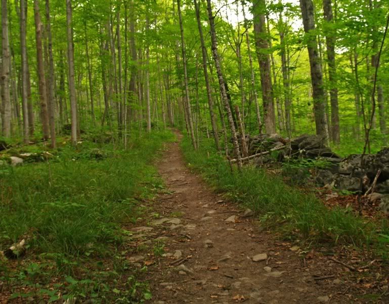
Trails go everywhere, which made finding the 'waterfalls' impossible the first time. I think I walked the whole loop through the 175 acres. Then I came back, saw my car, realized I had made an entire loop, then decided to follow a small dried up stream bed to the left of the immediate trailhead. About a half mile in - I came to the falls!
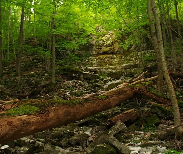
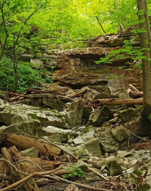
I thought the stream source was limestone - which I know flows all year, so it obviously wasn't the case. I'm wondering how long in the year the water actually flows. One of the ledges had a few drips of water coming down, so ti had some moisture associated with it.
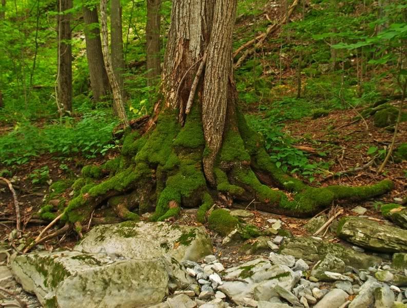
I knew I was in the right place because of 'old mossy', the happy tree:
How does NYfalls.com designate waterfalls? Do they have to flow all year to be considered for a 'waterfall' status? The land that this is on is very nice. It reminded me a lot of Bluff Point State Park in Connecticut that I used to mountain bike in - very glacial - but without water, it was kinda dissapointing.
Trails go everywhere, which made finding the 'waterfalls' impossible the first time. I think I walked the whole loop through the 175 acres. Then I came back, saw my car, realized I had made an entire loop, then decided to follow a small dried up stream bed to the left of the immediate trailhead. About a half mile in - I came to the falls!
I thought the stream source was limestone - which I know flows all year, so it obviously wasn't the case. I'm wondering how long in the year the water actually flows. One of the ledges had a few drips of water coming down, so ti had some moisture associated with it.
I knew I was in the right place because of 'old mossy', the happy tree:
How does NYfalls.com designate waterfalls? Do they have to flow all year to be considered for a 'waterfall' status? The land that this is on is very nice. It reminded me a lot of Bluff Point State Park in Connecticut that I used to mountain bike in - very glacial - but without water, it was kinda dissapointing.
-
Matt
- President
- Posts: 13374
- Joined: Sun Apr 23, 2006 5:01 pm
- Camera Model: Olympus OMD EM-1 m1, m2; Panasonic GM5, Osmo Pocket
- Location: Rochester, NY
- Contact:
I'd say it's a waterfall. Seasonal waterfalls sure can be profiled here. I'm guessing in spring it's quite a site.
Thanks for checking this out and getting us some pics. I may hike this area when I'm in syracuse again.
Thanks for checking this out and getting us some pics. I may hike this area when I'm in syracuse again.

