Black Chasm
Posted: Sun May 15, 2011 9:48 am
Went to Black Chasm yesterday, after wanting to get there for a long time. It was a bit drizzly and wet, so we didn't explore as much as we wanted as the footing was a bit uncertain. And you want to be certain about your footing in this place. Black Chasm is part of Platte (Plaat) Clove in the Catskills, just south of Kaaterskill Clove. It contains Devil's Kitchen, Hell's Hole, and Platte Clove Falls which have been posted here many times. To get to Black Chasm, you hike the trail to the Devil's Kitchen leanto and cut off the trail just after the trail to Indian Head mountain, and head to the left and downhill to the top of the chasm. You can also hike to the leanto, which is situated right on the stream that leads into the chasm and follow it downstream. Both ways require a bit of bushwhack, but nothing very difficult. I would recommend cutting off from the trail instead of following the stream, it's a slightly easier route.
Once you get to the top of the chasm, there is a nice picnic spot at the top of the falls and a couple of small places to camp, though I'm not entirely sure if camping is allowed, but there was evidence that there had been camping there. We only saw the top two small waterfalls because we didn't have the time or inclination or feel it was safe enough to proceed farther down to the bottom of the main falls. The biggest problem is once you get down there, you have to climb back out, or keep going down until you hit the main stem of the creek in Platte Clove and then continue down that until you hit the trail that leads out the bottom. That would be a nice adventure, but not on a drizzly day making every rock wet and slippery and no car waiting at the bottom.
OK, only two pictures to show, but they are nice shots of the upper most waterfalls before the main plunge over the cliff into the chasm itself. Here's the upper one that has the campsites to the right and where we ate lunch.
[img2]http://img857.imageshack.us/img857/9875/dsc7049.jpg[/img2]
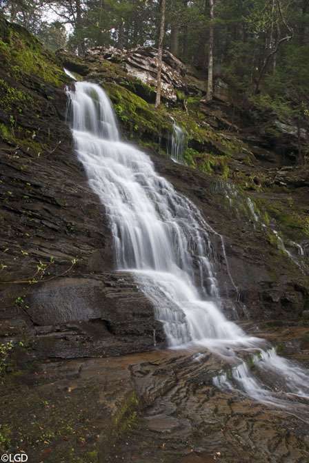
Just below that is this one, which was a chore to get to, and just off the picture to the right is the main drop, so it's a precarious place to be, as the hillside is very unstable, not to mention a bit wet & muddy from the rain.
[img2]http://img847.imageshack.us/img847/8871/dsc7035.jpg[/img2]
The main drop looked to be at least 100 feet or more, though some of that may have been a steep cascade along the rocks.
Once you get to the top of the chasm, there is a nice picnic spot at the top of the falls and a couple of small places to camp, though I'm not entirely sure if camping is allowed, but there was evidence that there had been camping there. We only saw the top two small waterfalls because we didn't have the time or inclination or feel it was safe enough to proceed farther down to the bottom of the main falls. The biggest problem is once you get down there, you have to climb back out, or keep going down until you hit the main stem of the creek in Platte Clove and then continue down that until you hit the trail that leads out the bottom. That would be a nice adventure, but not on a drizzly day making every rock wet and slippery and no car waiting at the bottom.
OK, only two pictures to show, but they are nice shots of the upper most waterfalls before the main plunge over the cliff into the chasm itself. Here's the upper one that has the campsites to the right and where we ate lunch.
[img2]http://img857.imageshack.us/img857/9875/dsc7049.jpg[/img2]
Just below that is this one, which was a chore to get to, and just off the picture to the right is the main drop, so it's a precarious place to be, as the hillside is very unstable, not to mention a bit wet & muddy from the rain.
[img2]http://img847.imageshack.us/img847/8871/dsc7035.jpg[/img2]
The main drop looked to be at least 100 feet or more, though some of that may have been a steep cascade along the rocks.


