
Went to Black Chasm yesterday, after wanting to get there for a long time. It was a bit drizzly and wet, so we didn't explore as much as we wanted as the footing was a bit uncertain. And you want to be certain about your footing in this place. Black Chasm is part of Platte (Plaat) Clove in the Catskills, just south of Kaaterskill Clove. It contains Devil's Kitchen, Hell's Hole, and Platte Clove Falls which have been posted here many times. To get to Black Chasm, you hike the trail to the Devil's Kitchen leanto and cut off the trail just after the trail to Indian Head mountain, and head to the left and downhill to the top of the chasm. You can also hike to the leanto, which is situated right on the stream that leads into the chasm and follow it downstream. Both ways require a bit of bushwhack, but nothing very difficult. I would recommend cutting off from the trail instead of following the stream, it's a slightly easier route.
Once you get to the top of the chasm, there is a nice picnic spot at the top of the falls and a couple of small places to camp, though I'm not entirely sure if camping is allowed, but there was evidence that there had been camping there. We only saw the top two small waterfalls because we didn't have the time or inclination or feel it was safe enough to proceed farther down to the bottom of the main falls. The biggest problem is once you get down there, you have to climb back out, or keep going down until you hit the main stem of the creek in Platte Clove and then continue down that until you hit the trail that leads out the bottom. That would be a nice adventure, but not on a drizzly day making every rock wet and slippery and no car waiting at the bottom.
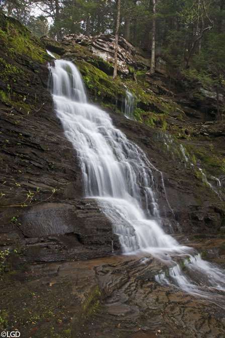
OK, only two pictures to show, but they are nice shots of the upper most waterfalls before the main plunge over the cliff into the chasm itself. Here's the upper one that has the campsites to the right and where we ate lunch.
[img2]http://img857.imageshack.us/img857/9875/dsc7049.jpg[/img2]
Just below that is this one, which was a chore to get to, and just off the picture to the right is the main drop, so it's a precarious place to be, as the hillside is very unstable, not to mention a bit wet & muddy from the rain.
[img2]http://img847.imageshack.us/img847/8871/dsc7035.jpg[/img2]
The main drop looked to be at least 100 feet or more, though some of that may have been a steep cascade along the rocks.
Black Chasm
-
hobkyl

- Moderator

- Posts: 2671
- Joined: Thu Aug 14, 2008 8:55 am
- Camera Model: Pentax K30
- Location: Victor, NY
-
HaloGirl

- Veteran Board Expert

- Posts: 1118
- Joined: Thu Sep 04, 2008 9:16 am
- Camera Model: Canon PowerShot SX10 IS & Applie iPhone
- Location: Ashburn, VA
- Contact:
Beautiful! Especially that first one. 
-
L_G_D
- Board Expert

- Posts: 629
- Joined: Fri May 29, 2009 2:29 pm
- Camera Model: Sony Alpha 700
- Location: Capital District area, upstate NY
Thanks, I would like to get back there and get to the bottom of the main falls, you can get an idea from this bing maps view
http://www.bing.com/maps/?v=2&cp=r0m37b ... orm=LMLTCC
hmmm... for some reason that link doesn't want to go to the right spot, so here it is
http://www.bing.com/maps/?v=2&cp=r0m37b ... orm=LMLTCC
hmmm... for some reason that link doesn't want to go to the right spot, so here it is
- black chasm
LGD
-
backpacker

- Board Expert
- Posts: 881
- Joined: Sat Sep 15, 2007 9:16 am
- Camera Model: Nikon D90, D40x, Lenses Nikor 12-24, 18-105 vr, 18-135, 70-300 vr, sigma 150-5oo os
- Location: Oriskany Falls
nice shots LGD
-
TobiasTicetonyk

- Rookie
- Posts: 13
- Joined: Mon Nov 28, 2011 5:55 pm
- Camera Model: Olympus Stylus 770 SW
- Location: Catskills
In the middle of October 2011 I took a visit to Black Chasm. I ended up camping there for 2 nights. Two slideshows: one is of just the waterfall and stream and the other is of the entire hike and camping ordeal. Both, as usual with my posts, have a cumbersome amount of pictures, but hey that's my style. The slideshows begin with pictures looking into Black Chasm from Huckleberry point, taken in April 2011. They end with a picture looking at the waterfall from the other side of Platte Clove, taken a couple weeks after I camped in the area.
Black Chasm:
http://cmd.shutterfly.com/commands/pict ... &album=425
Black Chasm & Hiking:
http://cmd.shutterfly.com/commands/pict ... &album=479

Waterfall from Platte Clove road (looking south):

Black Chasm:
http://cmd.shutterfly.com/commands/pict ... &album=425
Black Chasm & Hiking:
http://cmd.shutterfly.com/commands/pict ... &album=479
Waterfall from Platte Clove road (looking south):
Last edited by TobiasTicetonyk on Fri Dec 16, 2011 11:40 am, edited 1 time in total.
See all my pictures here:
http://mattscatskillpictures.shutterfly.com/
http://mattscatskillpictures.shutterfly.com/
-
L_G_D
- Board Expert
- Posts: 629
- Joined: Fri May 29, 2009 2:29 pm
- Camera Model: Sony Alpha 700
- Location: Capital District area, upstate NY
Wow, nice to see the falls from the bottom, it does look a bit wild down there. Have you ever gone further downstream? I bet there's more to see even before you get to the main stream in Platte Clove.
LGD
-
TobiasTicetonyk
- Rookie
- Posts: 13
- Joined: Mon Nov 28, 2011 5:55 pm
- Camera Model: Olympus Stylus 770 SW
- Location: Catskills
Yes, I made it about half way down. I grew up in this area so I was practically raised in Platte Clove and Peekamoose gorges, it's pretty spectacular down in the main stream. Have you been down there? I think going down the stream from black chasm is much safer than going down the other ways (hell hole). You can really get a good feel for it from my pictures of the stream in the slideshow.L_G_D wrote:Wow, nice to see the falls from the bottom, it does look a bit wild down there. Have you ever gone further downstream? I bet there's more to see even before you get to the main stream in Platte Clove.
This is where I stopped half way down to the bottom, I figured this was a good place to hang out, as I had my campsite back up at the top and I wanted to keep hiking the devil's path. The stream really turns into just a steep pile of single car garage-sized boulders (as is the upper part of the main platte clove stream), so the waterfall in the following picture is just one part of the long cascade that makes up the second half of the black chasm stream.
Where I stopped: Many small cascades along the stream, most were dammed up by boulders that have been wedged there for a long time, so there are actually many waist-deep spots.


The following picture is the stream terrain one would encounter for first half down, it gets notably steeper for the second half towards the bottom, but nothing you can't handle if you can make it to the bottom of the falls in the first place...

To get to the bottom of the main falls, the safest way is to stay on the western side (left if you are going downstream). Once you get to the top of the drop, traverse left until you come across a wide, steep gully formed by an old rockslide. This way, you go down a chute instead of the sheer cliffs. If you want more information about getting down there I'll elaborate. I just think that if one wants to get to the bottom or up to the top of Platte Clove, black chasm is the way to go. Why the DEC does not recommend this to people, I don't know. But they should- people die to get down there, because there is parking access on the top of the other way (which idiots really ^@%#ed up the bottom parking area when I was a teenager, that really ruined it for me and many others). So everyone thinks Hell Hole is the way to go- but in my opinion Black Chasm is much safer if you go down the gully I described. Maybe I'm just non adventurous but I'd rather take the safer route (well... "safe" for Platte Clove standards
OK this is the last of my rambles, but another reason I'm going on and on and on about this is while I was on my subsequent Devil's Path adventure after coming up from Black Chasm, I had told many groups about my route when they asked where I was heading. They then disrespectfully and ignorantly assume/accuse me of not knowing what I'm doing, that I'm going get myself killed, as if Platte Clove is some suicidal adventure canyon. They obviously don't know what they're talking about and obviously don't know the area (funny thing is while I was at that little cascade I showed above, a man in his 80s came up the stream- we had a good talk about this). The reason they assume this, is because too many kids/adults don't know the area well, so they have take the obvious route down, the route that gets them killed. The Catskills are not some grand wilderness, there are no secrets, DEC rangers MUST know of this route, but prefer to keep it secret so people just don't go down, maybe for good reason since there are many many many tires, washing machines, cars, and assorted garbage down there. They don't understand that people WILL go down, even if it means going the way that gets them killed. Yeah... I don't even know what I'm talking about anymore...
See all my pictures here:
http://mattscatskillpictures.shutterfly.com/
http://mattscatskillpictures.shutterfly.com/

